People are worried due to flood situation in Bihar, cracks in embankments in India-Nepal border districts
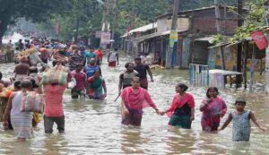
Flood in Bihar: Bihar’s flood situation remained dire because of reported embankment breaches along a number of rivers, which mostly affected areas close to the border with Nepal. Although several minor rivers have seen their water levels drop, over 16 lakh people are still in danger due to floods; authorities confirmed that no deaths have been recorded as of yet.

Authorities report that on Sunday, September 29, at Madhkaul village in Sitamarhi, a breach occurred in the Bagmati River embankment and that excessive water pressure in West Champaran damaged the left bank embankment of the Gandak river, causing floodwaters to enter the Valmiki Tiger Reserve.
SOURCE AND CREDIT: ANI
#WATCH | Bihar: Several parts of Sitamarhi affected due to floods after the Mandar dam in Belsand Block of Sitamarhi district breaks
(Earlier visuals) pic.twitter.com/4PhnPa2hO1
— ANI (@ANI) September 29, 2024
#WATCH | Bihar: Flood-like situation witnessed in Muzaffarpur as water enters Bakuchi Power Grid complex in Katra. pic.twitter.com/eY6jxZeFnC
— ANI (@ANI) September 30, 2024
The state water resources department (WRD) released a statement that read as follows: “Mild seepages on the left and right embankments in Belsand, Parsauni, Bargainia, and Rasalpur blocks of Sitamarhi district, as well as in Piprahi, Puranhiya, and Sheohar blocks of Sheohar district, were reported and immediately repaired due to the unexpected increase in the flow and water level of the Bagmati River.”
Nishikant Kumar, the executive engineer of the Bagaha flood control division, was suspended in reaction to the damage due to his carelessness and inability to work well with the local authorities in order to coordinate. The WRD emphasized the gravity of the issue by stating, “We are managing the flood risk by taking all necessary precautions.”
6.61 lakh cusecs of water were discharged by the Birpur barrage on the Kosi River, the most in 56 years. The agency said, “This level of discharge is unprecedented; the last maximum was 7.88 lakh cusecs in 1968.”
In a similar vein, the Gandak Valmikinagar barrage discharged 5.62 lakh cusecs, the most since 2003. To protect public safety, traffic has been stopped close to the Kosi barrage as a precaution.
The minister of water resources, Vijay Kumar Choudhary, gave the assurance that teams are always keeping an eye on embankments and would act quickly to stop any erosion or hazard. “Our teams are constantly on guard, and we are ready for any situation, so there’s no need to worry,” he told the media report.
On Sunday, reports of water rushing over the embankments came from Kiratpur and Valmikinagar in Darbhanga. Following two to three days of nonstop rain, the water levels in the Gandak, Kosi, Bagmati, Burhi Gandak, Kamla Balan, Mahananda, Bagmati, and Ganga have been increasing across the state. Numerous locations in the surrounding districts have rivers that touch or run above the danger threshold as a result of Nepal’s catchment regions’ constant rainfall, the minister said.
Further, according to officials, excessive river water flooded low-lying parts of West and East Champaran, Gopalganj, Araria, Supaul, Katihar, Purnea, and numerous other districts after a large outflow of water from the Birpur and Valmikinagar barrages.
A Flash Flood Warning is Issued by IMD for many Districts
Since the IMD forecasted significant rain and warned of the possibility of flash floods in several areas of the state, an alert has already been issued for a number of districts. There is a chance of heavy rain in districts like West and East Champaran, Sitamarhi, Sheohar, Muzaffarpur, Gopalganj, Siwan, Saran, Vaishali, Patna, Jehanabad, Madhubani, and Bhojpur.
The IMD said that “low to moderate flash floods are at risk in these districts.”
The fact that the water levels at numerous gauge sites are now above danger thresholds highlights the continued risk of flooding in the area. The Kamla Balan River’s water level at the Jhanjharpur gauge site is 52.10 meters, 2.10 meters over the danger threshold, while the Lalbekia River’s water level at the Gowabari gauge site is 72.70 meters, 1.55 meters above the danger mark.
Furthermore, the Mahananda River’s Taiyabpur and Dhegraghat gauge sites, which are at 66.81 and 37.22 meters, respectively, are above the danger criteria by 0.81 and 1.57 meters.


